
Summer may not even be over yet, but predictions for winter weather in our region have already been made.
The Old Farmer’s Almanac says a milder and drier winter is ahead with most snow falling around the holidays and later months.
“Fewer snow days could ease commutes, but not as we get ready to usher in 2026,” the almanac said.
Snow
What we know:
Snowfall, along with precipitation, is expected to be below normal this upcoming winter.
You can prepare for the region’s snowiest periods in late December, early January and late February, according to the almanac.
Last winter, 8.1 inches of snow fell in Philadelphia, while New York City and Washington D.C. both saw over 15 inches.
Temperatures
Local perspective:
The almanac says the region will enjoy above-normal temperatures this winter with the coldest periods popping up in mid-to-late December and early and late January.
The Philadelphia region experienced its coldest winter in 10 years in 2024-25, with the city hitting its lowest temperature of 10 degrees on January 21, according to the National Weather Service.
Meanwhile, New York City also hit a low of 10 degrees just one day later, and Washington, D.C. dipped to 15 degrees on January 22 and 23.
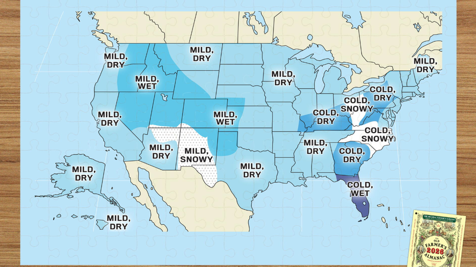
2025-26 winter forecast
Big picture view:
The U.S. weather summary for this winter is described by the almanac as “mostly mild with pockets of wild,” saying to expect a slightly mild winter while warning some regions to brace for a sharper chill.
“Don’t lose track of your snow shovels and umbrellas,” Old Farmers Almanac Editor Carol Connare said. “Most areas will experience near-normal to slightly milder temperatures, but from the Appalachians south through the Southeast and Florida, and westward across the Ohio Valley, we’re predicting a colder-than-normal winter.”
What’s shaping the winter outlook?
Dig deeper:
Several factors are impacting the almanac’s predictions for the 2025-26 winter season:
- Solar Cycle 25 peaked, which historically warms the Earth’s average temperatures.
- La Niña is fading and transitioning in the Pacific to neutral conditions.
- The Atlantic Multidecadal Oscillation (warm) and Pacific Decadal Oscillation (cool) remain stable, influencing regional storm patterns.
- The Quasi-Biennial Oscillation is shifting, which can affect polar vortex position, sending cold air southward.
- The polar vortex may wobble, which would plunge bursts of frigid air and snow into the U.S.
The Source: Information from this article was sourced from the Old Farmer’s Almanac.