Tropics Quiet For Now, Will Wake Up In September
The next tropical depression could develop in the eastern Atlantic as soon as the upcoming week, though a more active period for tropical storms and hurricanes could hold off until at least mid-September, typically the peak time of the year in hurricane season.
The Next Tropical Wave
A cluster of thunderstorms and weak low pressure system known as a “tropical wave” is expected to move west off the African coast into the Atlantic Ocean Sunday.
These tropical waves are important because they are often the seeds of future tropical storms during hurricane season.

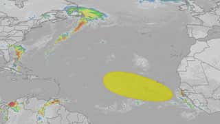
Possible NHC Development
(The possible area(s) of tropical development according to the latest National Hurricane Center outlook are shown by polygons, color-coded by the chance of development over the next seven days. An “X” indicates the location of a current disturbance.
)
What Could Happen
This tropical wave will continue to move toward the west-northwest next week over the eastern Atlantic Ocean between Africa and the Lesser Antilles.
According to the National Hurricane Center, this tropical wave could undergo “some slow development” in the upcoming week.
However, this system may have to battle both wind shear and pockets of dry, stable air in the eastern Atlantic, both nemeses of tropical systems.
Even if it does develop, we have plenty of time to watch it. By the weekend of Sept. 6-7, it could still be hundreds of miles east of the Lesser Antilles.
Assuming it develops at all, it’s far too soon to know if this system would ever pose a threat to the Caribbean or any part of the U.S. It could also simply recurve out into the open Atlantic beyond that time, as Tropical Storm Fernand just did.
The next Atlantic tropical storm will be named Gabrielle.

Currrent Wind Shear, NHC Development Area
(Areas of strong wind shear, the difference in wind speed and direction with height, are shown in purple. High wind shear is hostile to mature tropical cyclones and those trying to develop.
)
When It Could Turn More Active
According to NOAA’s Climate Prediction Center, activity could perk up in the Atlantic Basin starting in mid-September, and that could last for a few weeks.
That’s when an environment more supportive of tropical development — including lower wind shear and more moist, unstable air — could gradually work its way into the Atlantic Basin.
That lines up with the typical mid-September peak of the Atlantic hurricane season.
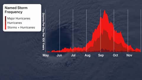
This graph shows the average Atlantic Basin storm, hurricane and major hurricane tallies through the season. The peak of hurricane season, historically, has been around the second week of September.
(Data: NOAA/NHC)
So far this season, we’ve been pretty fortunate. We’re near an average pace for both storms (six) and hurricanes (one). The season’s only hurricane, so far — Erin — avoided a landfall, though it did bring flooding rain to the Leeward Islands, as well as coastal flooding, rip currents and some winds to the East Coast.
However, about 70% of the season’s activity typically occurs from September onward.
Develop or refresh your hurricane plans now, while it’s quiet, before a hurricane threatens.

2025 Season Hurricane Tracks, So Far
(Data: NOAA/NHC)
Jonathan Erdman is a senior meteorologist at weather.com and has been covering national and international weather since 1996. Extreme and bizarre weather are his favorite topics. Reach out to him on Bluesky, X (formerly Twitter) and Facebook.